CSR Geomatics
In 2017, CSR – Auroville Centre for Scientific Research – created a CSR Geomatics cell. Geomatics is a discipline dedicated to the “collection, distribution, storage, analysis, processing, and presentation of geographic data or geographic information […] it consists of products, services and tools involved in the collection, integration and management of geographic data. It includes geomatics engineering (and surveying engineering) and is related to geospatial science (also geospatial engineering and geospatial technology).
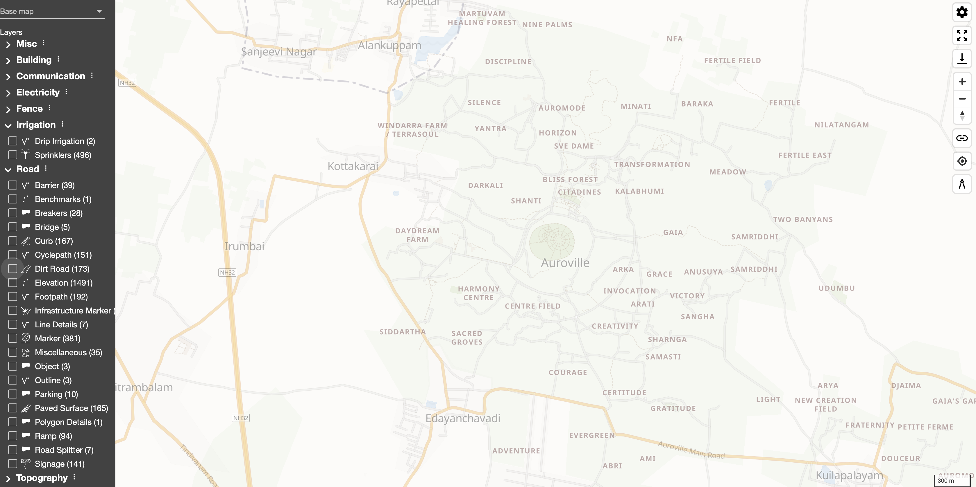
- A detailed, accurate standardized topographic survey has been conducted in the Matrimandir compound, International Zone, Residential Zone, and in the school compounds. The Industrial Zone and the Cultural Zone will follow, along with the Administrative Area.
- The work is carried out using DGNSS (Differential Global Navigation Satellite System) combined with Total Station. More than 1,80,000 ground level points have been surveyed so far, with a 3D accuracy in the range of 1-2.5 cm.
- All existing features visible on the surface of the surveyed area, including buildings, roads, trees, fences, infrastructures, water features, have also been surveyed with the same accuracy, in order to generate a topographic map.
- A series of missions have been carried out in the Residential Zone with an UAV (Unmanned Aerial Vehicle – drone), to obtain an aerial georeferenced ortophotomosaic, and to verify the reliability of this system when compared to a traditional survey.
- A survey of existing collective Sewage Treatment Plants has been conducted, along with a preliminary STP Health check-up assessment.
- Daily rainfall readings from more than ten manual raingauges, and several weather parameters as measured by three automatic weather stations are regularly recorded.
- A systematic campaign of water levels monitoring on about 55 wells is being conducted, and bi-weekly readings have been recorded since 2016.
- Three automatic pressure sensors have been installed into selected wells to automatically monitor water table level fluctuations, regularly transmitting data to a receiving base station.
- Some ultrasonic digital flow meters have been acquired, calibrated and tested, then installed to automatically measure water flowing through selected pipelines and borewells, ready to regularly transmit data to a receiving base station.
- A LORA-Wan radio receiving base station has been acquired, calibrated, tested and installed on a dedicated tower in CSR campus. Another receiving base station has been assembled and mounted in a large Auroville farm, to monitor water consumption used for agriculture there.
- A dedicated Open Source software has been coded to process all data received and stored into a PostGRE-SQL database, and a web interface (https://gis.avcsr.org) has been published to share all collected data, including topographic survey data.
- Technical historical data of about 350 Auroville wells has been compiled and stored into the database.
- Through the combination of all the above information and data, a complex geospatial algorithm has been created to theoretically quantify runoff potential.
The idea behind this project is to gather and consolidate geographical and related information, from many sources, in a "Geographic Information System" (GIS).
The data is shared with the community freely. Users can download information in multiple formats: CSV for data, GeoPackages or ShapeFiles for geographical information, etc. With a rigorous approach and using up-to-date processing tools, accurate data can then be easily accessible and reused in all kinds of domains, or just for any one's research. It is protected by a Creative Commons copyright (see below): data must be shared without commercial purpose, and the Auroville Geomatics Studio must be credited.
Web Portal Link: https://gis.avcsr.org/dashboard
A major effort is in process to survey the whole Auroville area with great accuracy, improving the base maps and layers for all kind of applications.
We are also collecting water related data (rain fall, well levels, etc), in order to improve the management of water in the community.
Get in Touch
See Also